|
 Geography, Landscape and Mills
Introduction
Watermills were a staple of some villages, most towns, and all cities from the ancient world onwards. Mills provided the power to grind grain into the principal processed food, flour, which fed society right into the modern period. And as populations grew, simple hand-mills, or querns, were unable to keep up with demand for flour. More importantly for the Middle Ages, however, feudal lords who had the resources to build mills also had the power to enforce mandatory milling (and fees) at those mills and saw mills as a great source of income (and control). At the same time, two interlocked logics encouraged the building of more and more watermills for agricultural purposes. Simple economies of scale argued for the construction of mills, so anyone who was able to (either economically or through the license of a lord or town council) did so. In any event, the farmers bringing grain to and taking flour away from the mills needed those mills sited where they were useful to the farmers, as well as where they were able to do useful work. Other types of mills, such as lumber, paper, or fulling mills, had similar needs regarding siting; they needed to be close to the timbermen, papermakers or cloth merchants. Otherwise a mill was about as useful as a truck stop on a two-lane dirt road.
Regardless of the reasons that a person, town, or lord might want a mill, and independent of the economic and material ability to build a mill, mills require certain conditions in order to run, and run effectively. We will deal with each type of mill separately below, but speaking geographically, mills need to be situated within the environment so that natural and social resources can be harnessed to best effect. For natural resources, this means water flow for watermills and wind for windmills; both need to be situated in the landscape in such a way so that the raw materials can arrive at the mill and the finished product can be taken from the mill economically and effectively. For flour and grist mills, this meant the grain had to be relatively close at hand to the mill, with a nearby market for flour. Other uses of mills — to saw wood, to full cloth, and later to pulp rags for paper, among them —also had certain requirements that conditioned the placement of mills in the landscape.
The goal of this lesson is to explain to students why mills appeared where they did and have students then explore their local surroundings for evidence of the once-common milling industry in every city, town, or even rural village.
WatermillsThe Requirements of Watermills
Watermills need a source of water to turn their waterwheels and provide power to the millstones, sawblade, or other industrial machinery. Any site with flowing water will do, to some extent, but some are better than others. By the end of this section, students should be able to consider the following questions and pose solutions to the others:
There are 3 basic types of waterwheels: horizontal, undershot, and overshot. Horizontal waterwheels revolve in the horizontal plane (which means, confusingly, their axles are vertical) much like a top-load washing machine. The undershot and overshot waterwheels are both types of vertical waterwheels, which rotate like a Ferris wheel. The undershot wheel's lower blades or paddles dip into the stream and are rotated by the moving water passing the mill. The overshot wheel, by contrast, has a flume that delivers water to the top of the wheel and the weight of the water falling into the wheel's buckets turns the wheel by the force of gravity.
It is apparent, then, that the type of stream one has to work with will probably determine the sort of waterwheel one can even build. Overshot wheels, for example, have to be situated in a stream where there is sufficient fall of water equal to the diameter of the wheel. In theory, a millwright could build an overshot wheel of any diameter —1 foot, even — but for these wheels to be strong enough to turn millstones, a drop of at least 10 feet, and sometimes as much as 30 is desirable. Therefore, overshot wheels are only possible in a very hilly area, and are often sited near natural waterfalls. If no natural waterfalls are available, a dam could be built some way upstream and a small, level canal, or leat, built leading to the mill, which is situated some way downstream of the dam. By this time, the water level from the millpond can be significantly higher than the mill itself, providing enough drop for the water to power the wheel.
Undershot wheels, on the other hand, can be as large as the millwright wants to make them, rising up above a stream, since only the lower paddles are immersed in the water. The limiting factor here, however, is that the water needs to be moving by the mill with some considerable velocity to have enough force to turn the blades. If the stream is too shallow, or too lazy, too little force will be imparted to the blades to turn the mill's machinery. Therefore, horizontal mills often appear in river valleys on relatively sizeable streams or rivers, and here, too, often a small dam or weir may be constructed to divert and concentrate the water into the millrace.
Finally, the horizontal waterwheel required that a narrow channel or pipe lead from the water course to the wheel pit. This type of waterwheel was the least expensive to build and usually always gave way to one of the other types because although it required very little quantity and head of water to run, it was necessarily limited in power. Partially this was due to inherent limitations in the designs, but it was also due to insufficient knowledge of how to best design the horizontal blades to take advantage of the water hitting them. (It is an interesting irony that since the 19th century, virtually all waterpower has come from turbines, the modern high-efficiency version of the horizontal waterwheel.)
Landscape
So how can students find mill sites or old mills in their local landscapes? There are three ways to approach this: topographically, toponymically, or cartographically.
Students can explore old maps, phone directories, town histories, and the existing fabric of towns as clues to where mills once stood within individual towns. Further, in an era before mechanized transport, mills needed to be placed no more than a few miles apart for goods to move easily to and from them. Where waterpower was available, some mills were more likely to be located near their raw materials than others - iron mills often needed to be near forests as the charcoal used to fuel them, although light, was bulky and awkward to transport (interestingly, the iron ore might move some considerable distance). Agricultural mills needed to be sited in the center of populations and agricultural fields, subject as always to the availability of water to power the mills. More specialized industrial mills usually clustered in cities, although sometimes the waste effluent from them caused problem for other townsfolk.
Above all, the logic of the mill was the logic of water. Water made the mills run, and performed all the functions ingenious medieval and colonial millers could ask of it. In the 12th century, Bernard of Clairvaux described the role of water in milling as follows: century:
The [river] Aube... passes and repasses the many workshops of the abbey, and everywhere leaves a blessing behind for its faithful service. The river climbs to this height by works laboriously constructed, and passes nowhere without rendering some service, or leaving some of its water behind. It divides the valley into two by a sinuous bed, which the labor of the brethren, and not Nature, has made, and goes on to throw half of its waters into the abbey, as if to salute the brethren and seems to excuse itself for not coming in its whole force, the canal that receives it being too small for it. If sometimes the stream, swollen by an inundation, rushes on with violent current, it is stopped by a wall, under which it is obliged to pass and so turned back upon itself, meets and checks the descending stream. Entering under the wall which, like a faithful porter allows it to pass, the stream first hurls itself impetuously at the mill; there, lashed into foam by their motion, it grinds the meal under the weight of the millstone and separates the fine from the coarse by a sieve of fine tissue. Already it has reached the next building where it fills a boiler and is heated for brewing, that drink may be prepared for the brethren, if it should happen that the vintage [wine] should not respond kindly to the labor of the vine-dresser�. But not even yet is its usefulness completed, for the fullers established near the mill call it to their aid; it is only right that, as in the mill, care is taken for the food of the brethren, so by these their clothing should be prepared. But the river does not hesitate nor refuse any who require aid; and you may see it causing to lift and drop alternately the heavy pestles, the fullers' great wooden hammers, or foot-shaped blocks (for that name seems to agree better with the treading work of the fullers) and so relieves them of the heaviest part of their labor.
When it has spun the shaft as fast as any wheel can move, it disappears in a foaming frenzy; one might say it had itself been ground in the mill. Leaving it here it enters the tannery, where in preparing the leather for the shoes of the monks it exercises as much exertion as diligence; then it dissolves in a host of streamlets and proceeds along its appointed course to the duties laid down for it... such as cooking, sieving, turning, grinding, watering, or washing, never refusing its assistance in any task. At last... it carries away the waste and leaves everywhere spotless.... How many horses would be worn out, how many men would have weary arms if this graceful river, to whom we owe our clothes and our food, did not labor for us? [1]
Thus the river powered everything from brewing to milling to clearing out the latrines at the end. Consequently, the mill and water-powered technology in general tended to be the most important technology for any medieval community.
Towns that date from the colonial period proper as well as the early Republic and later often began with the mill. As David Nye put it,
Americans viewed mills not merely as transformers of raw materials and local economies but as the seeds of new communities... the mill was a dynamic first cause; towns grew around it. Edward Kendall observed American conditions in 1808...: "To this mill, the surrounding lumberers, or fellers of timber bring their logs, and either sell them, or procure them to be sawed into boards or plank, paying for the work in logs. The owner of the saw-mill becomes a rich man; builds a large wooden house, opens a shop, denominated a store, erects a still, and exchanges rum, molasses, flower, and port, for logs. As the country has by this time begun to be cleared, a flower[flour]-mill is erected near the saw-mill. Sheep being brought upon the farms, a carding machine and fulling-mill follow. For some years, as we may imagine the store answers all the purposes of a public-house [saloon]. The neighbors meet there, and spend half the day, in drinking and debating. But the mills becoming every day more and more a point of attraction, a blacksmith, shoemaker, a tailor, and various other artisans and artificers, successively assemble. The village, however, has scarcely advanced thus far, before half of its inhabitants are in debt at the store, and before the other half are in debt all round. What therefore, is next wanted is a collecting attorney... whom the store or tavern-keeper receives as a boarder, and whom he employs in collecting his outstanding debts, generally secured by note of hand. "But as the advantage of living near mills is great, even where there is not (as in numerous instances there is) a navigable stream below the cataract... so a settlement, not only of artisans, but of farmers, is progressively formed in the vicinity; this settlement constitutes itself a society or parish; and, a church being erected, the village, larger or smaller, is complete."[2]
Thus, the importance of the mill cannot be overstated.
Exercises
Notes
Windmills
The other type of mill used to grind grain, as well as for other industrial uses (although less commonly), was the windmill. Windmills originated in the near east in the later first millennium C.E. (Sometimes 9th century Asia Minor — modern day Turkey — is mentioned, but we don't know for sure.), but by the later 12th century, they had spread or had been independently (re)invented in England and the Low Countries (Holland and the Netherlands).
Windmills tend to be smaller than watermills in terms of power output and they also tend to take up less space on the ground. For one thing, the windmill does not need to be next to a river, nor does it need the millrace running from upstream to power the wheels. On the other hand, the windmill needs to be placed in a windy location, either on top of a hill or near the coastline where winds are unobstructed and relatively constant. But as the building of a windmill is rarely larger than a small house, they could also be found in urban settings, especially where the town was on a hill (as in some of the Quebec and Upper Canada [Ontario] windmills form the 18th and 19th centuries) or was a coastal port town (Both New York and Newport, RI had windmills right in the town in the 17th century.).
Locations
Since windmills tended to be placed either on exposed hills or near the seashore, locating them in the colonial context can be easy, although as you might expect, there were few windmills inland or in heavily forested areas where wind was not constant. In addition, although one of the best places to put a windmill would be on top of a tall hill or ridgeline (often the site of wind farms for electrical power generation today), this is a very inconvenient place for the farmers to bring their grain, which was generally grown in the valleys. Consequently, if you are considering locating the historic site of a windmill, coastal regions remain your best bet.
Many of the same exercises from the watermill section can be extended to windmills, although often determining whether a place with "mill" in its name was for a windmill or watermill can be difficult. If there was a river present, it was likely a watermill, but if on a hill, then a windmill was likely.
Cultural Traditions
The functioning of technologies is not always immediately apparent to an observer, and the skills in building, maintaining, and running any large machine are skills that need nurturing and generational support. Hence, windmills tended to be strongly regional and even national in character. The Dutch are to this day identified with windmills, as are the Greek islands.
Explore some of the areas that are known to have been windmill intensive, such as Long Island in NY, Acquidnick Island in RI, and Nantucket and Martha's Vineyard in MA. What nationality of settlers settled in these places? See for example, the use of mills in Colonial Cities.
ResourcesBooks
Internet Sites
Activities for Students
Here we have a selection of geographical exercises for students to complete that will help them understand the location of mills as they relate to the natural environment.
Texas Watermills
In this map of the state of Texas, students will be able to compare the locations of watermills and animal-powered mills.
Nevis Windmills
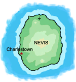 The small Caribbean island of Nevis is a perfect case study of how natural resources determine mill placement. Look at the images of Nevisian mills to the right and notice the striking distribution of windmills. It should be obvious that they are clustered in a certain way. Find out why.
In the case of windmills, there is primarily one resource [wind!], so find out what the wind patters around Nevis are. Where is Nevis? Why are the winds like they are? What about the landscape determines local wind patterns?
This work is based on the archaeological surveys by Marco Meniketti and David Landon: external link
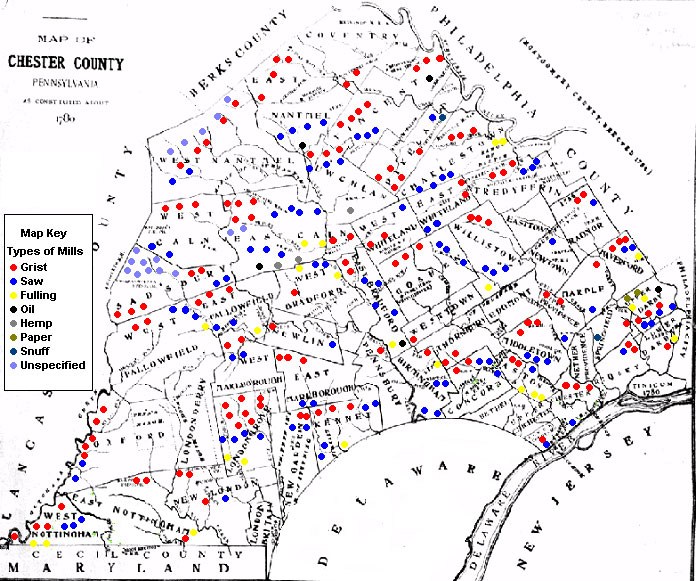
Colonial Pennsylvania Mills
Consider this map of the distribution of mills in 18th-century Chester County, near Philadelphia.
Another way to look at the distribution of mills is through census records. Below is a small extract of various mill types by county in 1773. Students could graph that data on a map of PA counties and then discuss why they see the distribution that they do.
Return to:
In-Depth Articles
 |
|||||||||

|